I-80 (Interstate 80) Road Conditions


I-80 State Weather Links
I-80 Road Conditions for June 12, 2026
Whole-route summary: Today’s I-80 impacts are primarily construction, lane restrictions, shoulder closures, bridge work, and ramp closures. The most notable ramp closures or ramp impacts are in California, Utah, Nebraska, Iowa, Illinois, Indiana, Pennsylvania, and New Jersey. No weather conditions are included.
- Major ramp closures and ramp impacts: Treasure Island Road off-ramp in San Francisco; Crystal Springs Road / Exit 148A and Drum Forebay / Exit 150 ramps in California’s Sierra corridor; westbound I-80 to southbound I-215 in Utah; Nebraska Exit 445 ramp to I-80 eastbound; Iowa Exit 121 ramp to Jordan Creek Parkway; Illinois Chicago Street, Center Street / Meadow Avenue, and southbound I-55 to eastbound I-80 ramps; Indiana Ripley Street / US 6 / IN 51 ramps and Gary milepost 4.9 / 5 ramps; Pennsylvania Route 940 / Exit 273 ramps; and New Jersey Exit 42 ramp roadwork.
- Major construction corridors: California’s Sierra corridor near Kingvale, Crystal Springs, Drum Forebay, and Yuba Gap; Utah’s Parleys Canyon work zones; Wyoming work zones near Evanston, Green River, Patrick Draw, Rawlins, Elk Mountain, and Cheyenne / Pine Bluffs; Nebraska work zones from Kimball through Omaha-area segments; Illinois I-80 reconstruction in Will County; Ohio construction in Mahoning and Trumbull counties; Pennsylvania reconstruction in Mercer County, the Lehigh River Bridge area, and Bellefonte; and New Jersey I-80 shoulder and ramp work.
- Longest-duration ramp closures: Illinois Chicago Street ramps and Center Street / Meadow Avenue ramps are tied to multi-year reconstruction; Pennsylvania Route 940 ramp closures are part of the I-80 Lehigh River Bridge project; Indiana Lake Station ramp closures are tied to bridge construction; and California’s Treasure Island Road off-ramp remains in a long-term construction closure.
I-80 California Road Conditions
State links: Caltrans I-80 Road Conditions | Caltrans QuickMap | 511 Bay Area Traffic Alerts
- San Francisco, Treasure Island Road: I-80 eastbound off-ramp to Treasure Island Road is closed for long-term construction through January 1, 2027.
- Placer County, Crystal Springs Road / Exit 148A: Eastbound I-80 on-ramp and off-ramp at Crystal Springs Road are closed until further notice. Exit detour: continue eastbound to Baxter and return westbound to Crystal Springs. Entrance detour: travel westbound to Alta, then return eastbound.
- Placer County, Drum Forebay / Exit 150: Eastbound I-80 on-ramp and off-ramp at Drum Forebay are closed through November 20, 2026. Exit detour: continue eastbound to Blue Canyon and return westbound. Entrance detour: travel westbound to Baxter, then return eastbound.
- Near Kingvale: Drum Forebay Drainage Restoration work has I-80 lane closures in place around the clock, scheduled through 7:00 p.m. on June 19, 2026.
- Nevada County, Yuba Gap: Westbound I-80 off-ramp at Yuba Gap is closed until further notice due to the westbound crossover. Detour: continue westbound to Emigrant Gap and return eastbound to Yuba Gap.
- West Sacramento, Yolo County: Westbound I-80 connector to eastbound US 50 is listed for nightly construction closure from 8:00 p.m. to 5:00 a.m., Monday through Saturday, through June 12, 2026.
I-80 Nevada Road Conditions
State links: Nevada 511 Road Conditions | Nevada 511 Road Condition List | Nevada 511 Traffic Events
- Nevada I-80: Nevada 511’s current roadway and traffic-event text listings did not show a specific active I-80 ramp closure or I-80 construction-location item for today.
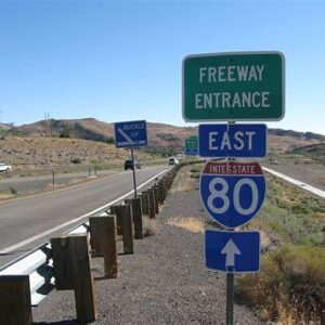
I-80 Utah Road Conditions
State links: UDOT Traffic | UDOT Construction
- Parleys Canyon, East Canyon Road to Lambs Canyon / Exits 134-137: I-80 is reduced to one lane nightly from 8:00 p.m. to 6:00 a.m. for paving work.
- Salt Lake County, 2300 East to Exit 130: I-80 is reduced to one lane nightly from 8:00 p.m. to 6:00 a.m. for paving work.
- I-80 / I-215 interchange: Westbound I-80 ramp to southbound I-215 is closed through mid-August 2026.
- Parleys Canyon corridor: UDOT’s active I-80 work includes repaving, bridge improvements, fiber-optic installation, and culvert upgrades; the current driver impacts are the nightly lane reductions and the westbound I-80 to southbound I-215 ramp closure listed above.
I-80 Wyoming Road Conditions
State links: WYDOT I-80 Route Report | WYDOT Travel Map | WYDOT Construction Projects
- Near Evanston, mileposts 4.5-6.25: Left lane closed for bridge deck, approach slab, and bridge railing replacement.
- Near Lyman, mileposts 28.03-34.29: Mill, overlay, traffic-control, and structure work are active; delays are expected.
- Green River tunnels, mileposts 88-91: Tunnel rehabilitation and lighting work have traffic running head-to-head in the eastbound tunnel. Speed is reduced to 35 mph and legal-width-only restrictions are in place.
- Near Rock Springs, eastbound mileposts 106-107: Left lane closed for road work.
- Patrick Draw area, mileposts 141-155: Milling, paving, bridge rehabilitation, and rest-area surfacing are active. Construction-zone speed limit is 65 mph.
- Eastbound Bitter Creek Rest Area, milepost 144.2: Rest area is closed until further notice.
- Creston Junction to Rawlins, mileposts 199.05-210.98: Mill-and-overlay work is active, with stopped traffic conditions and delays up to about 10 minutes.
- Near Elk Mountain, eastbound mileposts 240-248.1: Right lane closed for asphalt pavement work and bridge replacement.
- Cheyenne to Pine Bluffs area, mileposts 382.15-393.4: Concrete slab repair, milling, grinding, overlay, sealing, and bridge replacement work are active, with traffic shifts and lane restrictions.
I-80 Nebraska Road Conditions
State links: Nebraska 511 | Nebraska 511 Map
- Kimball area: Eastbound I-80 has bridge construction between 2 miles west of Kimball and Kimball.
- Kimball area: I-80 in both directions has bridge construction between 1 mile west of Kimball and 2 miles east of Kimball, with a 13-foot width restriction.
- Kimball to Sidney corridor: I-80 in both directions has construction work between 2 miles east of Kimball and 11 miles west of Sidney, with a 12-foot width restriction.
- West of Sidney: Eastbound I-80 rest area 6 miles west of Sidney is closed.
- Ogallala area: I-80 in both directions has construction work between Ogallala and 6 miles east of Ogallala, with 65 mph speed limit and an 11-foot width restriction.
- East of Ogallala: Long-term road construction is active 5 miles east of Ogallala, with 65 mph speed limit and an 11-foot width restriction.
- Paxton area: I-80 in both directions has long-term road construction between Paxton and 3 miles east of Paxton, with a 12-foot width restriction.
- East of Paxton: I-80 in both directions has construction work 4 to 14 miles east of Paxton, with 65 mph speed limit and a 12-foot width restriction.
- North Platte area: I-80 in both directions has road maintenance operations 1 to 6 miles west of North Platte.
- North Platte to east of North Platte: I-80 in both directions has construction work between North Platte and 5 miles east of North Platte, with 65 mph speed limit and a 12-foot width restriction.
- West of Gothenburg: I-80 in both directions has construction work 5 to 13 miles west of Gothenburg, with an 11-foot width restriction.
- Gothenburg area: I-80 in both directions has bridge construction between 5 miles west of Gothenburg and Gothenburg, with a 12-foot width restriction.
- Cozad area: Westbound I-80 has construction work near Cozad.
- Cozad to west of Lexington: I-80 in both directions has long-term road construction between Cozad and 6 miles west of Lexington, with 65 mph speed limit and an 11-foot width restriction.
- West of Lexington: I-80 in both directions has construction work 5 to 6 miles west of Lexington.
- Grand Island to Aurora area: I-80 in both directions has guardrail repair between 8 miles east of the Grand Island area and 3 miles east of the Aurora area.
- Emerald area: I-80 in both directions has nighttime construction work 1 to 5 miles west of the Emerald area.
- Emerald area to Lincoln: I-80 in both directions has long-term road construction between 4 miles west of the Emerald area and Lincoln, with 55 mph speed limit and a 12-foot width restriction.
- Melia area to La Vista: I-80 in both directions has nighttime construction work between 4 miles west of the Melia area and La Vista.
- Papillion to east of Gretna: Westbound I-80 has nighttime construction work between Papillion and 2 miles east of Gretna.
- Chalco to Omaha: I-80 in both directions has nighttime construction work between Chalco and Omaha.
- Exit 445: Road closed at the Exit 445 ramp to I-80 eastbound.
I-80 Iowa Road Conditions
State links: Iowa 511 | Iowa Work Zone Data Feed
- Dallas County, Exit 121 / Jordan Creek Parkway: Westbound I-80 exit ramp to Jordan Creek Parkway North is partially closed for road construction through October 30, 2026 at about 5:00 a.m. The shoulder and one ramp lane are closed; one general ramp lane remains open.
- Cass, Adair, and Dallas counties, IA 173 to Exit 100 near Dexter: Eastbound I-80 right shoulder is intermittently closed for road construction through June 18, 2026 at about 4:30 p.m.
- Cass, Adair, and Dallas counties, IA 173 to Exit 100 near Dexter: Westbound I-80 right shoulder is intermittently closed for road construction through June 18, 2026 at about 4:30 p.m.
I-80 Illinois Road Conditions
State links: I-80 Will Traffic Alerts | I-80 Will Project
- Joliet, Chicago Street interchange: Westbound I-80 ramps to northbound and southbound Chicago Street are closed through 2028.
- Joliet, Chicago Street interchange: Northbound and southbound Chicago Street ramps to eastbound I-80 are closed through 2028.
- Joliet, Center Street / Meadow Avenue interchange: Ramps at Center Street / Meadow Avenue are closed while the interchange is reconstructed. Center Street / Meadow Avenue over I-80 is closed between Wheeler Avenue and Morgan Street. The ramp from eastbound Meadow Avenue to eastbound I-80 remains open.
- I-55 / I-80 interchange: Southbound I-55 ramp to eastbound I-80 is closed and is scheduled to reopen in fall 2026.
- Ridge Road to Wheeler Avenue: I-80 has a 12-mile work zone with traffic shifted. Two lanes remain open in each direction, but lanes are narrowed and shoulders are closed through the work zone.
- Center Street to Chicago Street: I-80 and the Des Plaines River bridge corridor are under reconstruction on a new alignment.
I-80 Indiana Road Conditions
State links: Indiana 511 / TrafficWise | Indiana 511 Event List
- Lake Station, milepost 15, between US 6 and Clay Street: Westbound I-80 entrance ramp is closed for roadwork. The closure is listed as northbound Ripley Street to westbound I-80 / I-94 entrance ramp closed.
- Lake Station, Ripley Street to eastbound I-80 / I-94: Southbound US 6 / IN 51 ramp to eastbound I-80 / I-94 is closed for bridge construction through October 31, 2026 at 5:00 p.m.; detour is in operation.
- Lake Station, Ripley Street to westbound I-80 / I-94: Northbound US 6 / IN 51 ramp to westbound I-80 / I-94 is closed for bridge construction through October 31, 2026 at 5:00 p.m.; detour is in operation.
- Gary, milepost 4.9: Eastbound I-80 exit ramp is closed.
- Gary, milepost 5: Westbound I-80 exit ramp is closed.
I-80 Ohio Road Conditions
State links: OHGO | ODOT Traffic Advisories
- Trumbull County, Hubbard Township: I-80 eastbound just west of the Pennsylvania state line has lane restrictions for a pavement replacement project.
- Mahoning County, Meander Reservoir to SR 46: I-80 eastbound and westbound are reduced to two lanes, with traffic shifted to the outside shoulder and right lane.
- Mahoning County, SR 11 to west of the Ohio Turnpike: I-76 / I-80 has lane closures for pavement repairs and resurfacing, with work scheduled into late October 2026.
I-80 Pennsylvania Road Conditions
State links: 511PA | 511PA Construction | PennDOT I-80 Reconstruction Projects | PennDOT I-80 over Lehigh River Bridge
- Mercer County, Ohio state line to mile marker 5: I-80 reconstruction is active in West Middlesex Borough and Shenango Township. Work includes pavement reconstruction, bridge work, drainage, guiderail upgrades, signing, lighting, pavement markings, and related highway improvements.
- Mercer County, Route 318 bridge in Shenango Township: Route 318 bridge replacement and widening are part of the I-80 reconstruction work in the Ohio state line to mile marker 5 corridor.
- Carbon / Luzerne counties, I-80 Lehigh River Bridge area: I-80 westbound Ramp B off-ramp to Route 940 is closed as part of Stage 2 bridge construction.
- Exit 273 / Route 940: PA 940 on-ramp to I-80 eastbound remains closed as part of the I-80 over Lehigh River Bridge improvements.
- I-80 Lehigh River Bridge traffic pattern: Eastbound traffic has been shifted onto the newly constructed eastbound bridge, and westbound traffic has been moved onto the existing eastbound bridge using median crossovers.
- Bellefonte interchange area: I-80 / I-99 high-speed interchange construction is active. The project builds high-speed ramps connecting I-99 and I-80 and removes the need for through I-80 / I-99 traffic to use the SR 26 stop-controlled interchange movements.
I-80 New Jersey Road Conditions
State links: 511NJ Traffic Map | 511NJ Active Construction Feed
- Hardwick Township to Knowlton Township: I-80 eastbound has left-shoulder roadwork between east of Exit 1 / Delaware Water Gap and east of Exit 2 / Worthington State Park from 7:00 a.m. to 4:00 p.m.
- Parsippany-Troy Hills Township, Exit 42 / US 202 / Littleton Road: I-80 westbound has ramp roadwork at Exit 42 from 7:00 a.m. to 3:00 p.m.
- Parsippany-Troy Hills Township to Denville Township: I-80 westbound has the right shoulder closed between west of Exit 42 / US 202 / Littleton Road and east of Exit 37 / CR 513 / Hibernia Avenue from 7:00 a.m. to 3:00 p.m.
I-80 Road Conditions Overview
In the western mountain states on I-80 (CA, NV, UT, WY), winter brings heavy snowfall, chain/traction requirements, high-wind restrictions, and occasional multi-day closures—especially over Sierra Nevada passes, the Bonneville Salt Flats, Parley’s Canyon, and the Continental Divide. On I-80 in the Great Plains (NE, IA), blizzards and drifting snow can trigger short-term closures or “travel not advised” alerts, but the flat terrain lets plows clear the road quickly.
In the Midwest (IL, IN, OH), lake-effect snow and ice storms may cause brief whiteouts or crash-related stoppages, yet dense populations ensure fast reopenings. In the Northeast (PA, NJ), forested highlands and sudden snow squalls can lead to pileups and occasional shutdowns, while heavy commuter traffic around Philadelphia and New York keeps speeds down year-round.
Regional Hazards Along I-80
Nearly 2,900 miles coast-to-coast through 11 states
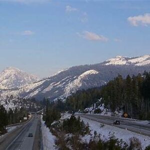
Mountain West:
Heavy winter snow (e.g. Donner Summit averages 30 ft/year)
Temporary closures or chain requirements
High Plains (WY, NE):
Blizzard conditions, fierce crosswinds
Ground blizzards and whiteouts
Great Lakes Corridor (IN, OH, PA):
Sudden lake-effect snow squalls
Visibility can drop to near zero
Midwest Summers:
Severe thunderstorms with heavy rain, hail, occasional tornadoes
These regional hazards highlight how wildly conditions can change along I-80. From deep snowpack in the Sierra Nevada to blizzard-driven whiteouts on the high plains, each segment demands awareness of its local perils. Summer storms in the Midwest add another layer of unpredictability, making I-80 a corridor of many faces.
I-80 Mountain Passes and Rock-Slide Areas
Crosses several high passes: Donner Summit (CA), Parley’s Summit (UT), Wyoming plateaus, Pennsylvania highlands
Winter challenges: steep climbs, icy surfaces, chain controls
Year-round risks: fog, high-wind gusts
Rock/mudslides: hillside cuts can block lanes after rain or freeze-thaw
Mountain segments of I-80 pack in elevation changes and geological hazards. Steep grades and narrow canyons make these stretches prone to snow buildup and sudden rockfalls. Even in summer, fog or gusty winds can catch drivers off-guard, underscoring the need for vigilance on these high-altitude sections.