Interstate 75 in Florida: Travel Guide to Road Conditions & Safety
Interstate 75 (I-75) is a major highway running north–south through Florida, spanning approximately 470 miles from the Miami area to the Georgia state line (Interstate 75 – AARoads – Florida). It serves as a vital corridor for both everyday motorists and commercial truckers, connecting key regions of the state. This guide provides a comprehensive overview of I-75 in Florida – including major cities along the route, seasonal weather patterns, typical road conditions, safety tips, and resources for live traffic updates.
Major Towns and Cities along I-75 in Florida
I-75 traverses the length of the Florida peninsula, linking South Florida to the Gulf Coast and north Florida. Key cities and towns along or near the interstate (from south to north) include (Interstate 75 – AARoads – Florida):
Miami (Hialeah/Miramar Area) – Southern terminus of I-75, beginning at the Palmetto Expressway in the northwest Miami suburbs (Interstate 75 – AARoads – Florida). Provides access to the greater Miami–Fort Lauderdale metropolitan area via connecting routes.
Naples – Western gateway to I-75 after Alligator Alley. The highway reaches Naples in Southwest Florida (Collier County) and turns north here (Interstate 75 – AARoads – Florida). Naples is a popular coastal city and the starting point for travelers heading across the Everglades.
Fort Myers – A major city in Southwest Florida (Lee County) along I-75’s Gulf Coast stretch (Interstate 75 – AARoads – Florida). Fort Myers and adjacent Cape Coral are served by multiple I-75 exits, making this a primary access point for Southwest Florida’s beaches and communities.
Punta Gorda/Port Charlotte – Mid-sized cities in Charlotte County that I-75 passes through (Interstate 75 in Florida – Wikipedia). The interstate skirts east of Punta Gorda and Port Charlotte, which are popular stopovers with services for travelers.
Sarasota & Bradenton – I-75 runs just east of Sarasota and Bradenton in the Suncoast area of Florida (Interstate 75 – AARoads – Florida). These Gulf Coast cities mark roughly the midpoint of I-75’s Florida route. The Sarasota/Bradenton region is known for its beaches and heavy seasonal traffic.
Tampa (Tampa Bay Area) – The interstate bypasses central Tampa on the city’s eastern side (Interstate 75 – AARoads – Florida). Tampa is the largest metropolitan area on I-75 in Florida. Major junctions here include the I-4 interchange (for Orlando) and I-275 (toward downtown Tampa/St. Petersburg). Expect urban traffic around the Tampa Bay region.
Ocala – A city in Central Florida (Marion County) known for horse farms. I-75 runs directly through Ocala (Interstate 75 – AARoads – Florida), providing access to Silver Springs and the Ocala National Forest.
Gainesville – Home of the University of Florida in Alachua County. I-75 passes just west of Gainesville (Interstate 75 – AARoads – Florida), with several exits serving the city. This area includes Paynes Prairie, a lowland savanna just south of Gainesville known for wildlife – and occasional fog (see Weather section).
Lake City – The last major Florida city on I-75 (Columbia County) before Georgia. Lake City is the crossroads with I-10 (east–west) (Interstate 75 – AARoads – Florida), making it a key junction for travelers heading toward Jacksonville or Tallahassee. I-75 leaves Florida north of here, near the town of Jennings, and continues into south Georgia.
Weather Conditions by Season
Florida’s climate can present various challenges for drivers on I-75, differing by season and region. From steamy subtropical summers in the south to occasional cool mornings in the north, being aware of the weather is crucial for travel planning. Below is an overview of typical conditions:
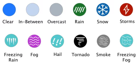
Summer (Wet Season & Hurricanes) – Summers along I-75 are hot, humid, and very rainy. Florida’s rainy season runs roughly May through October (Miami Weather Unveiled: Your Guide to the Tropical Climate by The Elser Miami), bringing daily afternoon thunderstorms with torrential rain and lightning. Downpours can be sudden, causing slick roads and reduced visibility. Summer is also hurricane season (officially June 1 to Nov 30 (NOAA predicts above-normal 2024 Atlantic hurricane season)), so tropical storms or hurricanes can impact travel. Drivers should be alert for weather advisories, as strong winds and heavy rain bands may lead to temporary highway closures. During major hurricanes, northbound I-75 can become extremely congested with evacuees (with reports of traffic jams where “there’s no way to avoid it” and even back-ups on alternate routes) (Evacuees test patience in heavy traffic but say their safety is worth it). Always heed evacuation orders and plan extra travel time if a storm is approaching.
Fall (September – November) – Early fall remains part of the hurricane season peak. September in Florida often brings lingering heat, humidity, and potential tropical systems. By October and November, conditions start to dry out and temperatures become more moderate. Fall is a transition to the dry season, so rainfall decreases significantly by late fall (Miami Weather Unveiled: Your Guide to the Tropical Climate by The Elser Miami). However, late-season hurricanes can occur (even into November), so travelers in early fall should stay aware of tropical weather forecasts. As autumn progresses, cooler mornings begin in North Florida, and the risk of hurricanes diminishes.
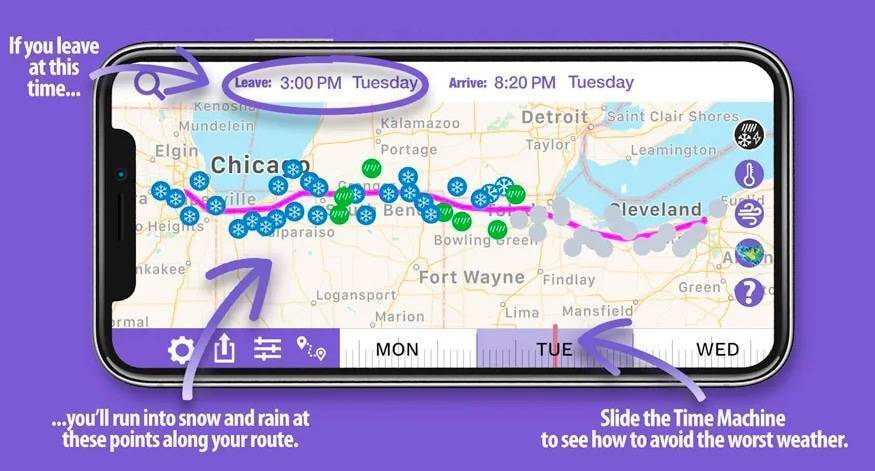
Winter (Dry Season & Fog) – Winter is the dry season in Florida, especially from December through February (Miami Weather Unveiled: Your Guide to the Tropical Climate by The Elser Miami). Along I-75, winter weather is generally mild: days are sunny and pleasant, and rain is infrequent. This is peak tourism and snowbird season due to the comfortable temperatures. However, winter mornings can bring dense fog in certain areas. Fog is common in low-lying regions and near water or marshes when nights are cool. One notorious spot is Paynes Prairie (near Gainesville), where cold morning fog (sometimes mixed with smoke from brush fires) has led to dangerous visibility drops. In 2012, that mix of fog and smoke caused a major pre-dawn pileup in the Paynes Prairie area, with multiple fatalities (11 year anniversary of a deadly 20 vehicle pileup on I-75). Drivers should use caution in fog – slow down, use low-beam headlights, and be prepared for sudden patches of low visibility in the early hours. Otherwise, winter provides the most road-friendly weather, free from rainstorms and hurricanes.
Spring (March – May) – Spring starts off dry and gradually becomes warmer and more humid. By March and April, mornings are cool and afternoons warm. It’s generally a pleasant time to drive, but as the dry season wanes, Florida enters its wildfire season. Occasionally, smoke from wildfires or controlled burns can drift across the highway – a hazard similar to fog. (When smoke combines with morning fog, visibility can drop to near zero, as seen in the Paynes Prairie incident (11 year anniversary of a deadly 20 vehicle pileup on I-75).) By late spring (May), temperatures climb and pop-up thunderstorms start appearing, signaling the approach of the summer rainy season. Drivers in spring should remain alert for early thunderstorms, and if smoke advisories are issued, be prepared for potential detours or delays.
We use cookies on our website to give you the most relevant experience by remembering your preferences and repeat visits. By clicking “Accept”, you consent to the use of ALL the cookies.
This website uses cookies to improve your experience while you navigate through the website. Out of these, the cookies that are categorized as necessary are stored on your browser as they are essential for the working of basic functionalities of the website. We also use third-party cookies that help us analyze and understand how you use this website. These cookies will be stored in your browser only with your consent. You also have the option to opt-out of these cookies. But opting out of some of these cookies may affect your browsing experience.
Necessary cookies are absolutely essential for the website to function properly. These cookies ensure basic functionalities and security features of the website, anonymously.
Cookie
Duration
Description
cookielawinfo-checbox-analytics
11 months
This cookie is set by GDPR Cookie Consent plugin. The cookie is used to store the user consent for the cookies in the category "Analytics".
cookielawinfo-checbox-functional
11 months
The cookie is set by GDPR cookie consent to record the user consent for the cookies in the category "Functional".
cookielawinfo-checbox-others
11 months
This cookie is set by GDPR Cookie Consent plugin. The cookie is used to store the user consent for the cookies in the category "Other.
cookielawinfo-checkbox-necessary
11 months
This cookie is set by GDPR Cookie Consent plugin. The cookies is used to store the user consent for the cookies in the category "Necessary".
cookielawinfo-checkbox-performance
11 months
This cookie is set by GDPR Cookie Consent plugin. The cookie is used to store the user consent for the cookies in the category "Performance".
viewed_cookie_policy
11 months
The cookie is set by the GDPR Cookie Consent plugin and is used to store whether or not user has consented to the use of cookies. It does not store any personal data.
Functional cookies help to perform certain functionalities like sharing the content of the website on social media platforms, collect feedbacks, and other third-party features.
Performance cookies are used to understand and analyze the key performance indexes of the website which helps in delivering a better user experience for the visitors.
Analytical cookies are used to understand how visitors interact with the website. These cookies help provide information on metrics the number of visitors, bounce rate, traffic source, etc.
Advertisement cookies are used to provide visitors with relevant ads and marketing campaigns. These cookies track visitors across websites and collect information to provide customized ads.