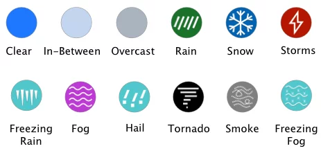
The map below shows the I25 weather conditions and weather radar for the next 6 hours. Interstate 25 is a major north/south highway functioning as a main route through the western United States. I-25 is mostly rural and follows along the base of the Rocky Mountains for nearly the entire trip.
This path provides a great view of the Rocky Mountains and stunning scenery that will not put you to sleep. It is 1,062 miles long and goes from Las Cruces, NM to Buffalo, WY passing through New Mexico, Colorado, and Wyoming.
Copyright 2025 Concept Elements LLC. | Privacy Policy | EULA
| Cookie | Duration | Description |
|---|---|---|
| cookielawinfo-checbox-analytics | 11 months | This cookie is set by GDPR Cookie Consent plugin. The cookie is used to store the user consent for the cookies in the category "Analytics". |
| cookielawinfo-checbox-functional | 11 months | The cookie is set by GDPR cookie consent to record the user consent for the cookies in the category "Functional". |
| cookielawinfo-checbox-others | 11 months | This cookie is set by GDPR Cookie Consent plugin. The cookie is used to store the user consent for the cookies in the category "Other. |
| cookielawinfo-checkbox-necessary | 11 months | This cookie is set by GDPR Cookie Consent plugin. The cookies is used to store the user consent for the cookies in the category "Necessary". |
| cookielawinfo-checkbox-performance | 11 months | This cookie is set by GDPR Cookie Consent plugin. The cookie is used to store the user consent for the cookies in the category "Performance". |
| viewed_cookie_policy | 11 months | The cookie is set by the GDPR Cookie Consent plugin and is used to store whether or not user has consented to the use of cookies. It does not store any personal data. |