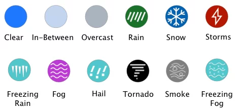
The map above shows I-35 weather conditions and radar for the next 12 hours provided by the National Weather Service. Interstate 35 is a major north/south interstate highway traveling through the heartland of America. Beginning in the south in Laredo, Texas traveling north to terminate at a signal traffic signal in Duluth, Minnesota.
I-35 is 1,568 miles long making it the ninth longest Interstate Highway and the third longest north/south Interstate highway in the United States. It passes through several major cities along the way: San Antonio, Austin, Dallas-Fort Worth, Oklahoma City, Wichita, Kansas City and Des Moines. Cutting through the center of America brings travelers through the tornado belt in the spring and possible blizzard conditions in the winter. For these reasons, pay close attention to the weather conditions on I-35.
Copyright 2026 Concept Elements Inc. | Privacy Policy | EULA
| Cookie | Duration | Description |
|---|---|---|
| cookielawinfo-checbox-analytics | 11 months | This cookie is set by GDPR Cookie Consent plugin. The cookie is used to store the user consent for the cookies in the category "Analytics". |
| cookielawinfo-checbox-functional | 11 months | The cookie is set by GDPR cookie consent to record the user consent for the cookies in the category "Functional". |
| cookielawinfo-checbox-others | 11 months | This cookie is set by GDPR Cookie Consent plugin. The cookie is used to store the user consent for the cookies in the category "Other. |
| cookielawinfo-checkbox-necessary | 11 months | This cookie is set by GDPR Cookie Consent plugin. The cookies is used to store the user consent for the cookies in the category "Necessary". |
| cookielawinfo-checkbox-performance | 11 months | This cookie is set by GDPR Cookie Consent plugin. The cookie is used to store the user consent for the cookies in the category "Performance". |
| viewed_cookie_policy | 11 months | The cookie is set by the GDPR Cookie Consent plugin and is used to store whether or not user has consented to the use of cookies. It does not store any personal data. |