Interstate 70 (I-70) in Colorado is one of the most scenic and challenging highways in the United States. Spanning from the Utah border through Denver and into the Rocky Mountains, I-70 is known for its rapidly changing weather, steep grades, and high elevations. If you’re traveling I-70 in Colorado, staying informed about current and forecasted weather conditions is essential for safe and efficient travel.
Weather Hazards on I-70 in Colorado
- Winter Snowstorms & Ice
From October through April, I-70 frequently experiences heavy snowfall, blizzards, icy roads, and chain law alerts, especially in high-elevation areas like Vail Pass and the Eisenhower Tunnel. Road closures and traffic delays are common during major snow events.
- High Elevation Challenges
The highway reaches over 11,000 feet in elevation, making it vulnerable to sudden weather changes. Temperatures can drop quickly, and snowfall can occur even in late spring or early fall.
- Summer Thunderstorms & Flash Flooding
In the warmer months, afternoon thunderstorms can bring lightning, hail, and localized flooding, especially in mountain canyons and steep terrain. Reduced visibility and slick roads are common hazards.
- Fog, Wind, and Rockslides
Dense fog is frequent in mountain valleys, while strong crosswinds can affect control, particularly for high-profile vehicles. Rockslides may occur after heavy rain or snowmelt, occasionally closing sections of I-70.
Key Areas for Weather Awareness on I-70
- Glenwood Canyon – prone to closures due to rockfalls and flash floods
- Vail Pass – often impacted by snow, ice, and traction control requirements
- Eisenhower Tunnel – subject to chain laws and visibility issues in winter
- Idaho Springs to Georgetown – frequent snow and narrow curves during storms
- Denver Metro – high traffic combined with snow or hail can cause major delays
Tools for Monitoring I-70 Colorado Weather
- COTrip.org: Real-time road conditions, cameras, and weather alerts from CDOT (Colorado Department of Transportation)
- Colorado 511: Dial 511 or use the mobile app for live traffic and weather updates
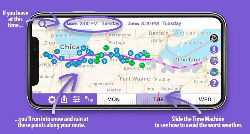
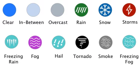
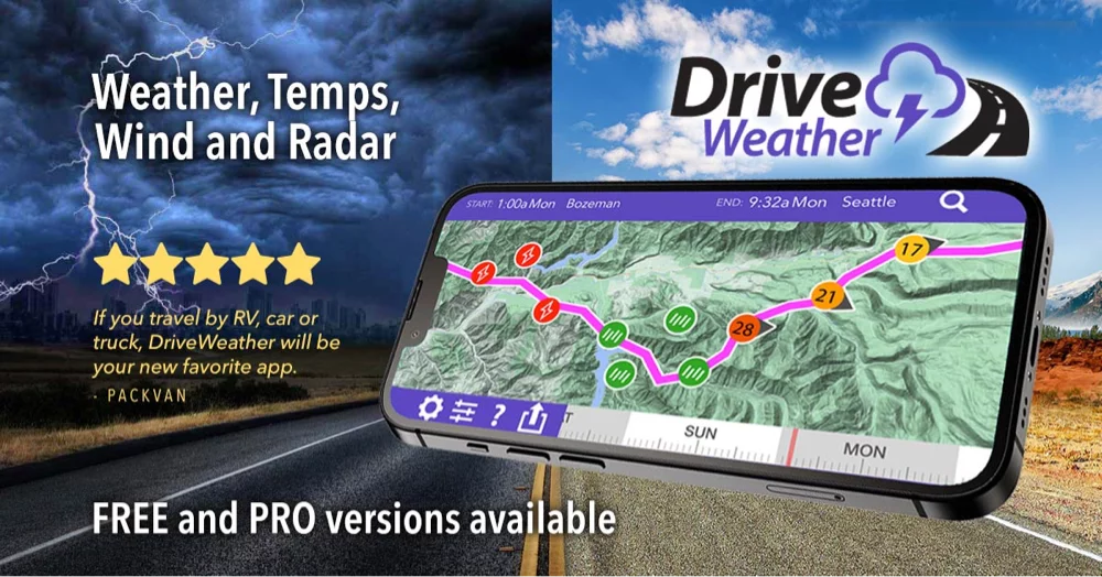
- Drive Weather App: Visualizes weather conditions along your entire I-70 route
- Weather Apps: Use NOAA, AccuWeather, or The Weather Channel to track radar and hourly forecasts
Pro Tip: Before traveling I-70 in Colorado, especially in winter, always check road closures, chain laws, and weather alerts. Pack emergency supplies, allow extra travel time, and be prepared for quick changes in mountain conditions.
When driving Colorado’s stretch of Interstate 70, keeping an eye on I‑70 Weather is crucial for navigating the high country safely. Winding more than 450 miles across the Rockies, Colorado’s I‑70 climbs above 11,000 ft at Loveland Pass and pierces the Continental Divide through the Eisenhower–Johnson tunnels, where sudden snow squalls and subzero temperatures can close lanes without warning.
In winter, avalanche control and icy fog add risk, while summer afternoons often bring high‑elevation thunderstorms and hail near Vail and Aspen. Beyond weather hazards, Colorado’s I‑70 corridor offers epic scenery: soak in steam‑rising pools at Glenwood Springs, admire the sheer red walls of Glenwood Canyon, ski world‑class resorts at Breckenridge and Keystone, or catch a sunset concert at Red Rocks Amphitheatre just outside Denver. Monitoring real‑time I‑70 Weather forecasts, snow advisories, wind warnings, or storm watches; helps you plan mountain passes, avoid closures, and focus on the unforgettable beauty of Colorado’s backbone.
I70 Colorado connects cities on I70 including Burlington, Seibert, Limon, Byers, Denver, Frisco, Vail, Beaver Creek, Glenwood Springs, and Grand Junction and spans east to west across the middle of Colorado. I-70 is the main interstate used to access ski resorts such as Vail and Beaver Creek in Colorado. The Colorado National Monument located just northwest of Grand Junction on I70 is a less traveled but beautiful National Park, especially when the weather is good with blue skies.