

The I-65 is an interstate that runs north and south and is 887 miles long. Beginning in Mobile, Alabama and ending in Gary, Indiana (depending on which way you go), the I-65 connects the four biggest cities in Alabama: Birmingham, Mobile, Huntsville, and Montgomery.
As Interstate 65 winds through Nashville, Tennessee, Louisville, Kentucky, and Indianapolis, Indiana, it passes near the Mammoth Cave National Park, the Bernheim Arboretum and Research Forest, the National Corvette Museum, and Fort Knox.
For the most part, driving along I-65 in the spring and summer puts you smack in the middle of beautiful views and awe-inspiring scenery. There are many attractions to visit, as you saw above, but for the most part, there’s a lot to enjoy just in watching the natural rolling hills go by.
However, when the wind starts to blow and the snow flies, you’ll want to keep off these roads, especially the ones through the middle of nowhere with little cover. Interstate 65 is a common place for weather conditions to deteriorate quickly. As the wind kicks up and the clouds gather, roads that are exposed for miles soon become treacherous.
That’s why it’s so important that you keep a map handy with storm warnings in the area. Weather apps are one of the best resources for keeping an eye on the weather, no matter where you’re located or where you’re going.
For push notifications directly from the National Weather Service, choose the Drive Weather App. You can download this app straight from Google Play on both Android and iOS phones. It’s a free resource truckers rely on to find the best road conditions possible to arrive home safely.
The Drive Weather App includes features to help you navigate your journey, no matter if you’re dealing with I-65 weather or weather conditions along any route. You can see the weather forecast in real time as you plan your route, and adjust your departure time as necessary to avoid the worst weather conditions.
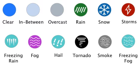
The interactive map on the Drive Weather App provides easy-to-read information you can reference as you track the weather. From your location, you’ll see the surrounding weather forecast notated in small icons. These icons refer to the sky as overcast, blue, or in between. Rain, snow, thunder, fog, hail, smoke, and haze are all notated as well. Plus, you can see wind speeds and keep an eye on the radar, too.
If you want to be prepared for any weather on your trip along Interstate 65, download the Drive Weather App today. It might just save you from life-threatening weather conditions.
Copyright 2025 Concept Elements LLC. | Privacy Policy | EULA
| Cookie | Duration | Description |
|---|---|---|
| cookielawinfo-checbox-analytics | 11 months | This cookie is set by GDPR Cookie Consent plugin. The cookie is used to store the user consent for the cookies in the category "Analytics". |
| cookielawinfo-checbox-functional | 11 months | The cookie is set by GDPR cookie consent to record the user consent for the cookies in the category "Functional". |
| cookielawinfo-checbox-others | 11 months | This cookie is set by GDPR Cookie Consent plugin. The cookie is used to store the user consent for the cookies in the category "Other. |
| cookielawinfo-checkbox-necessary | 11 months | This cookie is set by GDPR Cookie Consent plugin. The cookies is used to store the user consent for the cookies in the category "Necessary". |
| cookielawinfo-checkbox-performance | 11 months | This cookie is set by GDPR Cookie Consent plugin. The cookie is used to store the user consent for the cookies in the category "Performance". |
| viewed_cookie_policy | 11 months | The cookie is set by the GDPR Cookie Consent plugin and is used to store whether or not user has consented to the use of cookies. It does not store any personal data. |