I-80 Weather and Radar Updates — See Current Conditions and 12-Hour Wind and Temperature Forecasts. Get detailed I-80 forecasts and road conditions with Drive Weather.
I-80 Weather Road Conditions, Wind, Temps, and Live Radar
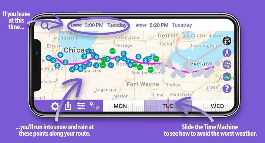
Plan Your Trip with Real-Time I-80 Weather Forecast Updates
When planning a road trip along I-80 (Interstate 80), staying informed about I‑80 Weather is essential for a safe and enjoyable journey. Stretching over 2,900 miles from San Francisco to Teaneck, New Jersey, I‑80 cuts across 11 states and presents a fascinating variety of weather patterns—from summer thunderstorms in the Midwest to heavy snowfall in the Sierra Nevada. One of the most notorious hazards is the frequent dangerous winds in Wyoming, where gusts can easily exceed 60 mph on the open plains.
Along the way, travelers can marvel at the glittering Bonneville Salt Flats, take in sweeping views of the Great Salt Lake, explore the historic Lincoln Highway Museum near Omaha, or enjoy the vibrant skyline of Chicago. Whether you’re tracking snow squalls in Nebraska or heat advisories in Nevada, monitoring I‑80 Weather helps you anticipate conditions and make the most of America’s historic coast‑to‑coast corridor.
We use cookies on our website to give you the most relevant experience by remembering your preferences and repeat visits. By clicking “Accept”, you consent to the use of ALL the cookies.
This website uses cookies to improve your experience while you navigate through the website. Out of these, the cookies that are categorized as necessary are stored on your browser as they are essential for the working of basic functionalities of the website. We also use third-party cookies that help us analyze and understand how you use this website. These cookies will be stored in your browser only with your consent. You also have the option to opt-out of these cookies. But opting out of some of these cookies may affect your browsing experience.
Necessary cookies are absolutely essential for the website to function properly. These cookies ensure basic functionalities and security features of the website, anonymously.
Cookie
Duration
Description
cookielawinfo-checbox-analytics
11 months
This cookie is set by GDPR Cookie Consent plugin. The cookie is used to store the user consent for the cookies in the category "Analytics".
cookielawinfo-checbox-functional
11 months
The cookie is set by GDPR cookie consent to record the user consent for the cookies in the category "Functional".
cookielawinfo-checbox-others
11 months
This cookie is set by GDPR Cookie Consent plugin. The cookie is used to store the user consent for the cookies in the category "Other.
cookielawinfo-checkbox-necessary
11 months
This cookie is set by GDPR Cookie Consent plugin. The cookies is used to store the user consent for the cookies in the category "Necessary".
cookielawinfo-checkbox-performance
11 months
This cookie is set by GDPR Cookie Consent plugin. The cookie is used to store the user consent for the cookies in the category "Performance".
viewed_cookie_policy
11 months
The cookie is set by the GDPR Cookie Consent plugin and is used to store whether or not user has consented to the use of cookies. It does not store any personal data.
Functional cookies help to perform certain functionalities like sharing the content of the website on social media platforms, collect feedbacks, and other third-party features.
Performance cookies are used to understand and analyze the key performance indexes of the website which helps in delivering a better user experience for the visitors.
Analytical cookies are used to understand how visitors interact with the website. These cookies help provide information on metrics the number of visitors, bounce rate, traffic source, etc.
Advertisement cookies are used to provide visitors with relevant ads and marketing campaigns. These cookies track visitors across websites and collect information to provide customized ads.