I-40 Weather and Radar

Check for the current I-40 Weather and Live Radar. Our weather map shows current weather road conditions and 12 hour weather, wind speed and temperature forecasts. Stay informed with detailed I-40 weather reports and real-time weather road conditions with Drive Weather.

I-40 Weather, Wind, Temps, and Live Radar Map

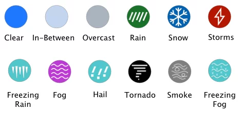
wind direction Thunderstorm Heavy Thunderstorm Hail Heavy Snow Light Snow Snow Fog Heavy Rain Light Rain Rain Dust Storm temperature wind Freezing Rain Light Freezing Rain Freezing Fog Smoke Haze Light Hail
Weather on WEATHER & RADAR Wind on WIND Temperature on TEMP  
Interstate weather legend
Interstate Weather Legend Mobile

I-40 Travel Weather & Road Trip Planning

I-40 (Interstate 40) sits along the southern half of the United States and runs east to west. Established in 1956, it is about 2,500 miles long and runs through California, Arizona, New Mexico, Texas, Oklahoma, Arkansas, Tennessee, and North Carolina. It is the third longest highway in the nation, after the I-90 and the I-80. 

Some of the major cities along the I-40 route include Flagstaff, Albuquerque, Amarillo, Oklahoma City, Little Rock, Memphis, Knoxville, and many cities in North Carolina. In the west, part of I-40 overlaps the historic Route 66, but the I40 is also great to travel if you’re looking for an Arizona Road Trip that begins in Phoenix and ends in Flagstaff. 

Many parts of the I40 span rivers big and small. In 2002, a barge collided with a bridge along I-40 in Oklahoma, causing the bridge member to fail and a 580-foot section of the bridge to fall into the Arkansas River. A total of 14 people were killed in this accident. In May of 2021, another bridge member was found to be faulty. Cracks appeared in a bridge member of the Hernando de Soto Bridge, causing it to close. 


Major Cities and Towns Along I-40

I-40 travels from the Mojave Desert in California to the Atlantic coast of North Carolina, passing through numerous cities and towns. Key stops (west to east) include many of the following:

  • California & Arizona: Barstow, CA (I-40’s western terminus) and Needles, CA lead into Kingman, AZ and Flagstaff, AZ – a high-elevation city and gateway to the Grand Canyon.
  • New Mexico & Texas: Gallup, NM and Albuquerque, NM (New Mexico’s largest city) are followed by the Texas Panhandle’s hub, Amarillo, TX.
  • Oklahoma & Arkansas: Oklahoma City, OK (state capital) anchors the route in Oklahoma, and Fort Smith, AR (near the Oklahoma border) leads into Little Rock, AR, Arkansas’s capital.
  • Tennessee: Memphis, TN (on the Mississippi River), Nashville, TN (country music capital), and Knoxville, TN mark I-40’s major urban centers across Tennessee.
  • North Carolina: In the Appalachian region, I-40 passes Asheville, NC, then through the Piedmont Triad with Winston-Salem and Greensboro, NC, and onward to the Research Triangle area (Durham and Raleigh, NC). Finally, it reaches Wilmington, NC on the Atlantic coast, I-40’s eastern terminus.

Historic Route & Scenic Drives

  • Route 66 Overlap
    Between Kingman and Holbrook, AZ, I-40 parallels America’s “Mother Road.” Road conditions here can vary—watch for rapid temperature swings at higher elevations and occasional rock-slide warnings.
  • Arizona Road Trip Highlight
    A popular segment runs Phoenix → Flagstaff. Elevation gain and mountain passes mean you may experience snow or ice in winter months, so check real-time I-40 weather updates before you roll.

Bridge Safety & Past Incidents

Bridges over major waterways demand extra attention:

  • 580-Foot Span Collapse (2002)
    A barge struck an Oklahoma River bridge member, causing a section to fall into the Arkansas River and tragically killing 14 people.
  • Hernando de Soto Bridge Closure (May 2021)
    Cracks in a critical support beam forced an immediate shutdown—underscoring the need for up-to-date I-40 structural alerts.

Always verify bridge-specific advisories when planning heavy loads or oversized hauls.


How to Stay Informed on I-40 Conditions

  1. Live Traffic Cameras & DOT Websites
    State Departments of Transportation provide webcams, construction maps, and incident logs.
  2. Mobile Traffic Apps
    Enable real-time push notifications for closures, detours, and severe-weather warnings along I-40.
  3. Weather Forecast Overlays
    Combine radar and road-temperature data to anticipate black ice, flash floods, or high-wind advisories.
  4. CB Radio & Trucker Networks
    On-the-ground reports from fellow drivers often offer the earliest heads-up on new hazards.

I-40 Road Conditions

Whether you’re hauling freight coast-to-coast or cruising for leisure, proactive I-40 road conditions is your best defense against unexpected delays and dangerous conditions. Before you set out, check:

  • Current lane closures and bridge status
  • Live weather radar for storms, snow, or high winds
  • Recommended detours for construction zones

Safe travels start with up-to-the-minute information—keep your eyes on the road and your apps updated!